

The Low-Altitude Economy Is Taking Off — But Airspace Management Isn’t Ready
By 2030, China’s low-altitude economy is projected to exceed ¥2 trillion (roughly $280 billion USD). The United States FAA estimates that commercial drone operations alone will contribute over $100 billion annually to the US economy within the same timeframe. Across Europe, Asia, and North America, urban air mobility corridors are advancing from pilot programs to infrastructure planning.
Yet beneath this momentum lies a structural problem that threatens to become the industry’s most consequential bottleneck: low-altitude airspace management has not kept pace with the ambitions of the industry it is meant to enable.
The challenge is not merely regulatory. It is architectural. The frameworks, tools, and institutions built to manage manned aviation over the past century are fundamentally mismatched with the operational reality of hundreds — eventually thousands — of unmanned aircraft moving through urban airspace simultaneously.
Why Legacy Systems Are Failing at Low Altitude
Traditional air traffic management was designed for a world where aircraft are large, slow to change trajectory, and operated by trained professionals communicating on standardized frequencies. Low-altitude operations break every one of these assumptions.
A delivery drone weighing 15 kilograms does not file a flight plan five days in advance. An eVTOL air taxi cannot wait two hours for manual coordination between civil and military airspace authorities. Emergency response drones need authorization in minutes, not days.
The mismatch manifests in four concrete failure modes that operators across every major market are encountering today:
- Approval latency: In many jurisdictions, commercial drone flight approvals still require multi-agency coordination that takes days. For time-sensitive logistics or emergency operations, this eliminates most of the use case entirely.
- Fragmented situational awareness: No single authority has a real-time, comprehensive picture of who is flying where at low altitude. Weather data, terrain models, population density maps, temporary flight restrictions, and live aircraft positions exist in separate systems that rarely communicate with each other.
- Static risk models: Airworthiness assessments — when they happen at all — rely on checklist-based human review rather than dynamic, multi-variable analysis. A route that was safe at 9 AM may be dangerous at 2 PM due to changed wind conditions, a temporary event below, or congestion from other operators.
- No full-lifecycle management: Most existing platforms address one phase of the flight: typically the filing step. The operational phases — pre-flight validation, in-flight monitoring, anomaly response, post-flight analysis — remain disconnected, creating accountability gaps that regulators are only beginning to grapple with.
The Policy Landscape Is Shifting — Faster Than Most Operators Realize
Governments are responding, and the pace of regulatory change is accelerating significantly.
In China, the State Council and Central Military Commission jointly issued the Regulations on the Administration of Unmanned Aircraft Flights in 2023, establishing the first comprehensive national legal framework for drone operations. In 2024, the Civil Aviation Administration of China (CAAC) followed with guidelines for a three-tier low-altitude flight service system spanning national, regional, and local levels. Provinces including Guangdong, Hainan, and Hunan are piloting streamlined approval systems that aim for same-day, and in some cases near-real-time, authorization.
In the United States, the FAA’s BEYOND and UTM Pilot Programs have been testing unmanned traffic management infrastructure since 2019. The European Union Aviation Safety Agency (EASA) has finalized its U-space framework, creating a structured regulatory environment for urban drone operations across member states.
The direction of travel is clear: regulators are converging on digital-first, data-driven airspace management as the only viable path to safe low-altitude scaling. The question for operators and technology providers is how quickly the infrastructure can catch up with the policy intent.
What Intelligent Airspace Management Actually Requires
The gap between where airspace management is today and where it needs to be is not primarily a regulatory gap — it is a technology and integration gap. Closing it requires capabilities that go beyond incremental improvements to existing systems.
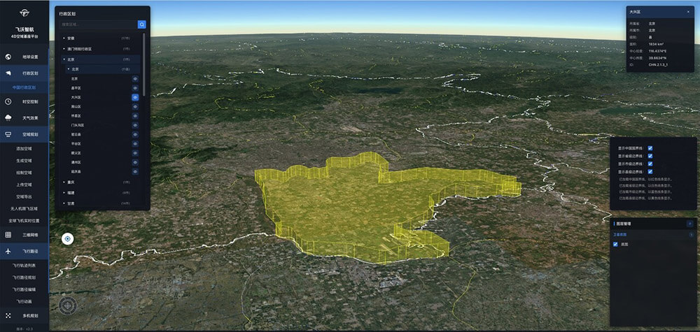
3D Digital Twin Airspace Visualization
Effective low-altitude management starts with a shared, accurate, real-time picture of the airspace. This means more than a map with colored zones. It requires a dynamic three-dimensional model that integrates terrain elevation, building footprints, active flight restrictions, live weather data, and current aircraft positions — updated continuously and accessible to all authorized stakeholders simultaneously. Static maps and PDF aeronautical charts are not adequate for managing operations at the density that low-altitude commerce demands.
AI-Powered Route Planning and Conflict Detection
The computational complexity of planning a safe route through urban airspace — accounting for restricted zones, other aircraft, terrain, weather, and aircraft performance parameters — is beyond practical human manual review at scale. AI planning algorithms capable of generating optimal, constraint-compliant routes in seconds are not a convenience; they are a prerequisite for any approval system fast enough to support commercial operations. Leading platforms are demonstrating route generation times measured in seconds, not minutes, with automatic conflict detection across all concurrent operations in the managed airspace.
Multi-Dimensional Airworthiness Assessment
Risk is not binary. A route is not simply “safe” or “unsafe” — it carries a risk profile that varies across weather conditions, altitude bands, underlying population density, aircraft type, and time of day. Intelligent airworthiness assessment systems synthesize these variables automatically, presenting risk maps that allow operators and controllers to make informed decisions quickly, rather than performing ad hoc manual checks against disconnected data sources. This shift from checklist-based to model-based risk assessment is one of the most consequential capability jumps available to the industry today.
Full-Lifecycle Flight Management
The full management cycle — planning, pre-flight validation, real-time monitoring, intervention capability, and post-flight analytics — must be integrated into a single operational picture. Platforms that handle only the filing step leave operators and regulators blind during the phases when incidents are most likely to occur. The operational data generated across thousands of flights also constitutes a critical feedback loop for improving route models, refining risk assessments, and informing future policy design.
Applications Leading the Way
The scenarios where intelligent low-altitude airspace management is delivering the most immediate value share a common characteristic: they involve high operational frequency, time sensitivity, or both.
Urban logistics operations — companies like JD Logistics, SF Express, and Meituan in China, Wing and Zipline internationally — are moving toward fleets that need to execute dozens to hundreds of flights per day per city. Manual approval processes do not scale to this frequency. Fleet management and air traffic coordination must be handled by integrated platforms capable of processing approvals, monitoring flights, and detecting conflicts automatically and continuously.
Emergency response represents the highest-stakes application. Wildfire monitoring, search and rescue, and disaster assessment operations need airspace access in minutes. The agencies running these operations cannot afford approval latency measured in business days, and the flight conditions they encounter — degraded weather, mountainous terrain, concurrent manned aircraft — demand the most sophisticated risk assessment capabilities available.
Municipal governments and civil aviation authorities are increasingly recognizing that without a capable digital management platform, they cannot safely permit the density of operations their low-altitude economy strategies require. The platform infrastructure is the policy — without it, the strategy remains theoretical.
Toward a Connected Low-Altitude Ecosystem
The long-term architecture of low-altitude airspace management will not be a single monolithic system. It will be an ecosystem of interoperable platforms connected through standardized data interfaces, serving different layers of the airspace from municipal corridors to regional networks. The platforms being built today are establishing the data standards, operational protocols, and integration patterns that will define this ecosystem.
Platforms that demonstrate integrated “see-manage-control-simulate” capability — real-time awareness, intelligent coordination, direct intervention capacity, and simulation-based planning — represent the architectural model that the industry is converging toward. Flyward’s 4D-Airspace Traffic Management Platform is one example of this integrated approach, combining high-precision 3D visualization, AI route planning, multi-dimensional airworthiness assessment, and full-process flight management in a single operational environment. Organizations evaluating platforms in this space can explore its capabilities through a free trial.
The Window for Getting This Right Is Now
The low-altitude economy does not have a technology problem — the drones, sensors, and aircraft are improving rapidly. It has an infrastructure problem. And like all infrastructure problems, the cost of getting it wrong compounds over time: premature incidents erode public trust, regulatory overreaction constrains legitimate operations, and the absence of reliable management systems prevents the density of operations that would make the economics work.
The organizations — operators, technology providers, and regulators — that invest seriously in intelligent airspace management infrastructure in the next two to three years will be the ones positioned to lead when the low-altitude economy reaches the scale everyone is projecting. The airspace is opening. The question is whether the management systems will be ready when it does.